|
|
Post by Eddie on Jun 2, 2020 22:39:02 GMT
The last 3 months has been taken up by new content soon to be released, but we'd like to report the Pway crew are well underway on the new track extension around the Lower Circle. Already they've laid track that eclipses the Edgware Road branch in length, and the current east end-of-tracks is just off the platforms at St James Park. Here is a grab of the track map, compare it with your Phase 2.1 version. 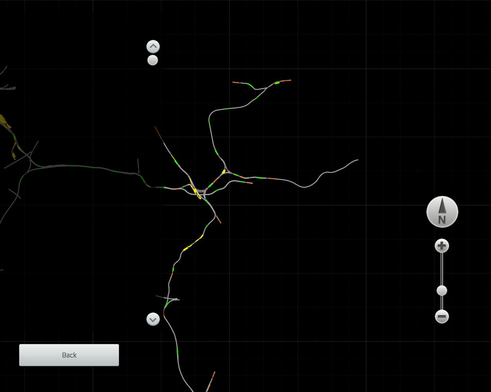 More news in this thread as cut/cover continues eastwards... |
|
|
|
Post by trabantdave on Jun 3, 2020 9:28:57 GMT
Looking good! Eddie - you are such a tease.....
|
|
|
|
Post by AlexTheMole on Jun 10, 2020 20:00:08 GMT
Fantastic!
|
|
|
|
Post by Eddie on Oct 3, 2020 13:24:35 GMT
Latest news is that we ripped up all the track and started again............... long story but it just wasn't accurate enough. We had problems with track paths and scaling issues with many of the platforms. It required a back to the drawing board approach to making our decals. The good news is that the new decals allowed very much more accurate pathing and scaling of the platforms. We have arrived at Whitechapel with all trackwork, tunnels, signalling sound properties, juice rails, and occlusions plus track infrastructure, speed limits and so on. Xavier has started building the stations and his first South Kensington is now finished. It blew Jimi and me away when we first saw this. In fact we had to share with you because it shows we have a team that can maintain the very high standard of station building on the VDL. When Xavier offered to make the Lower Circle stations, we both felt he was throwing himself in the deep end. Little did we suspect he is an Olympic Gold Medal winning swimmer. Both Xavier and Richard are capable of incorporating very high levels of detail and character into their creations. Anyway you be the judges here are the grabs I just took in 64 bit free roam.    [/url [/url
 free image hosting bb free image hosting bb  |
|
|
|
Post by Eddie on Oct 3, 2020 13:33:51 GMT
|
|
|
|
Post by Jimi on Oct 3, 2020 15:32:36 GMT
For those curious as to how we do it, this is an overview of the design and build process for Phase III (thus far) which involves the majority of the team each having skills in various processes.
WHERE DOES THE TRACK GO?
We have detailed scaled diagrams that when used appropriately tell us where the track path goes, gradients, tunnels, vents, signals, speed limits, etc. Step 1 is I clean those up (graphics editing) to only show what we need to know. Ed needs to know track path and gradients so his virtual P-way gang can carve a track bed and lay metals, and I need to know track properties, signal and speed limit info so I can later add those. As the charts are to a known scale, I can then place the fragments as overlay graphics onto Google Earth in their correct location. Xavier then took that info and employed various forms of magic to create TS decals of the areas we needed. When placed in the route as terrain decals, these show us surrounding geography and buildings, and also the track information we need. Here’s a screenie of the section from GRD to WHI showing the Google map and the track path graphics placed ready to create the decals.

The track map is the thin white strip going from low-left, around the Thames Embankment, and to upper-right, where you can see the triangle at ALD (Minories Jct) and the track continuing east to WHI. Close up it contains a lot of detail, but this view gives you a sense of the project scope. 12+ miles of tracks and 14 new stations. And a lot of tunnels.
PERMANENT WAY
Ed is a master track layer, having laid (IIRC) all the tracks on the VDL since we began. He has a knack for judging curves and gradients based on the track chart info so they “feel right” and meet LUL track standards and practices, including some very tight radii curves and X-overs. And single and double slips! So the next step is for Ed to use the decals to lay track, points and station platforms – the latter placed as offset lofts so they conform to the track paths. The screenie Ed showed back in June at the start of this thread represents about that point in the process. After that ,I edit the track properties defining track type, directionality, speed limits, sounds, etc.
Once track is laid we’ve learnt from experience the next step is to place tunnel objects where needed. As Phase III includes the “cut and cover” sections of the Lower Circle, we had to place both arched and rectangular tunnel sections as either lofts or discrete objects over the track which was running in a suitable trench. I got the easy job laying the lofted arch tunnel from GRD to SJP. Xavier did a remarkable and much harder job creating the rectangular tunnels from SJP all the way to ALD and WHI using bespoke objects. We have some very good cab ride video that helps out here, and also helps with signals placement, so we get it to look like the prototype. Diagrams only get you so far.
Final step is I add our bespoke LUL juice rails as lofts. There are standards and rules about how LUL lays juice rail. As LUL is (mostly) left hand running, the POS juice rail is also on the left hand side – unless there is a reason for it not to be. Examples of exceptions are some tunnels, bridges and nearside platform area, where the POS rail moves to the offside. We take a lot of time to get the details right. Roger (Our longtime LUL consultant) once told me to visualize the path of the conductor shoe on the train bogie, and that it must always join or leave a juice rail on a ramp. That determines a lot of the juice rail paths and gaps, especially across points. We also need the NEG center rail which needs to fork at junctions to cover both paths. It’s a lot of detail to do, but in the end it simply looks right.
Here's some examples where we have finished track work ready to add the station models.
Looking west from Tower Hill
Looking east from the bay road end at Tower Hill
POPULATING THE TUNNEL
A lot of the Lower Circle is in cut/cover tunnel and needs to look right so it feels realistic to drive. But before we make it “dark” I need to place and wire in all the required signals, speed posts and “count-up” boards and other clutter that populate the trackside, the six-foot and tunnel walls. We are grateful to JT for producing a very comprehensive LUL signal set, including tunnel variants, in their Met route. Phase III has had a big signals update with tunnel types replacing the previous versions on both the Upper and Lower Circle tunnel sections, and other places throughout the route where needed. Again the diagrams show us where things go, but videos (and anecdotal info) tell us exactly how an item is placed. Then I can add the tunnel occlusion objects that cause the darkness effect. After that, any editing requires wandering around the tunnel with the TS World Editor flashlight.
Approaching TOW heading east
STATIONS AND OTHER STRUCTURES
We have several guys on the team (Darren, Richard, Xavier) who are very adept at creating scenery objects using various modeling tools. Previously Darren has created the train cabs and Richard the majority of scenery. This time, to give folks a break, Richard is busy on the R49 cab so Xavier offered to build the Phase III stations. You can see the results in Ed’s posts above, and I think you’ll agree he’s captured the feel and atmosphere of the station, not just its appearance.
SCENERY
Ed as a long-time London cab driver knows London and surrounding area real well. And it’s usually he that places the majority of the scenery simply because he has a feel for what it looks like and the character of the area. There’s even scenery on the Circle as there are periodic vent areas (required in the early days of the District for venting smoke/steam) and you can see the buildings surrounding the vents if you look up. Also scenery surrounding any stations that are in part open to the sky. There’s also a ton of vegetation, courtesy of Xavier – who somehow seems to make it look real.
IT TAKES A VILLAGE
What you see in the end is a result of a team of guys each contributing their skills in specific areas but with an overall goal so in the end it all looks right, works correctly, and feels right. It has character. A fan once described it as a sensory overload – which is a wonderful compliment. And now you know a bit more about how we do it.
As someone once said, "All that's left to do is everything else". 13 more stations...
One day this will be Whitechapel
|
|
|
|
Post by Mike on Oct 3, 2020 17:43:51 GMT
Great work Gentlemen.
Mike
|
|
|
|
Post by mldaureol on Oct 3, 2020 20:55:04 GMT
Hi,
These pictures look really excellent.
Keep up the good work.
Looking forward to driving on this in the future.
Mike.
|
|
jmm
Station Staff

Posts: 21
|
Post by jmm on Oct 3, 2020 21:49:33 GMT
Congratulations! Very nice work!
|
|
|
|
Post by klmconcorde on Oct 4, 2020 13:18:00 GMT
It is good to see its starting to take some life, some things though that can be improved is that South Kensington Sign, It isn't using the correct London Underground Font, but that can be downloaded from here: fonts2u.com/london-tube.fontalso I highly recommend using VP's Grass Pack: www.vulcanproductions.co.uk/rb.html and using the Irregular Asset Tool for foliage production as using the irregular asset tool allows faster rendering and loading, the potential for a lot more detailed scenery without hitting frame rates. May I also suggest super elevation? as I have said before Super Elevation is very common on the Underground and the route won't seem the same without it. |
|
|
|
Post by Xavier on Oct 4, 2020 14:32:53 GMT
Thanks for the feedback.
I will correct the signs and make sure I double-check on subsequent stations. I do have a number of Johnston font versions and in a moment of lapse I probably chose the wrong thing.
As recommended as it may be, I am reluctant to use VP's Grass or Tree packs at this time, for two reasons. Firstly they are not wholly free from FPS hits. Having seen them used on a French route (Dijon - Vallorbe) they were relatively fps-hitting when benchmarked against other sets such as the virtualrailroads foliage, which were eventually swapped out to be used instead of VP's foliage. Secondly, it adds to the requirements list and the amount of different assets/folders TS has to load on the route, and this hits on performance and it's important for me personally not to make the requirements list any bigger than it has to be. And so if VP's foliage was added then something else will have to go and despite my best efforts in previous iterations I don't think it can be watered down any more.
Finally, I will consider the request of super elevation but it will have to be looked at towards the end of current development, and it does have limits. The easement tool restricts the range of curve radii you can have and over what distance you can lay which means for the super elevation to work you may have to diverge wildly off-course.
|
|
|
|
Post by klmconcorde on Oct 4, 2020 14:41:42 GMT
Thanks for the feedback. I will correct the signs and make sure I double-check on subsequent stations. I do have a number of Johnston font versions and in a moment of lapse I probably chose the wrong thing. As recommended as it may be, I am reluctant to use VP's Grass or Tree packs at this time, for two reasons. Firstly they are not wholly free from FPS hits. Having seen them used on a French route (Dijon - Vallorbe) they were relatively fps-hitting when benchmarked against other sets such as the virtualrailroads foliage, which were eventually swapped out to be used instead of VP's foliage. Secondly, it adds to the requirements list and the amount of different assets/folders TS has to load on the route, and this hits on performance and it's important for me personally not to make the requirements list any bigger than it has to be. And so if VP's foliage was added then something else will have to go and despite my best efforts in previous iterations I don't think it can be watered down any more. Finally, I will consider the request of super elevation but it will have to be looked at towards the end of current development, and it does have limits. The easement tool restricts the range of curve radii you can have and over what distance you can lay which means for the super elevation to work you may have to diverge wildly off-course. A lot of the FPS Hits actually come from the VP tree packs which I personally dislike for those reasons, however I found the VP Grass Pack is fantastic to use and should at least be trialled but thank you for bringing my feedback on board  |
|
|
|
Post by Jimi on Oct 4, 2020 14:41:56 GMT
Aryan - are you suggesting that the lower Circle, built largely in the 1830s used Superelevation? In cut and cover tunnels? Or just once again picking on something that you have been told multiple times will not happen? You can NOT retrofit superelevated track. As Xavier points out LUL uses very tight curve radii and the easements and terrain space required can not support it. And we are not prepared to sacrifice route path accuracy for a feature that is not required. Please - accept it and move on.
|
|
|
|
Post by Eddie on Oct 4, 2020 15:59:17 GMT
I can confirm as the guy who laid the track on top of scale drawings that following the track paths using easements are impossible. There may well be superelevation on parts of the Undergound network including the District , but the real life track layers weren't hampered by easements in TS. I'd put accurate pathing over super elevation every time. We took that decision a long time ago and it still stands.
|
|
|
|
Post by AlexTheMole on Oct 4, 2020 16:16:57 GMT
Superb work, once again hats off to the team! Cant wait for Phase III!! |
|
|
|
Post by Eddie on Oct 4, 2020 16:21:27 GMT
Thanks Alex, incidentally, where has your Friday night stream gone? .......... :-(
|
|
|
|
Post by AlexTheMole on Oct 4, 2020 17:09:39 GMT
I had to knock the streaming on the head, which has been a long time coming to be honest. It was costing me money and stress for no return and the channel had shown no growth since about this time last year. I tried and I have no regrets, but I'm more relaxed since stopping.
|
|
|
|
Post by expat16 on Oct 4, 2020 18:48:26 GMT
Thank you for all your hard work on this route.
Such great work!
|
|
|
|
Post by trabantdave on Oct 6, 2020 14:08:56 GMT
I always think when it goes a bit quiet on here that something is starting to rumble in the distance, and yet again you guys have proven me right! Looking forward to the release in the fullness of time, and for the updates here to keep the interest alive - Many thanks for your hard work, attention to detail, and determination to produce a really accurate simulation of all aspects of SSL operation!
|
|
|
|
Post by Jimi on Oct 7, 2020 1:36:57 GMT
Thanks Dave! We regret the update info was a bit later than we intended, but the decision to rip it all up and re-do cost a bit of time. But was very worth the effort. If you were to use the TS World Editor tape measure you'd now find the s station platforms are within about 1% of correct length, and D78, C69 and S7 will fit correctly. Plus it's 12+ miles of new track and 14 stations which is our largest update to date. And mostly in tunnels.
The fun will be that you will now be able to drive a DR Ealing or Wimbledon-Tower Hill service that would likely run about an hour over very different track types and scenery. Or drive a Circle (Inner or Outer) Edgware Rd-Aldgate. And the long-awaited Circle ex-ALD Outer holding up a DR ex-ALDE at OB31. And you could drive either train. And we'll extend the QD paths. And it's now all new JTLU tunnel signals and speed signs and so on in the tunnels (upper and lower Circle).
So hopefully a lot to keep you all busy for a while. The bones of the lower Circle are done, and the stations are under construction. There are bound to be 1001 tweaks to scenery lighting signals et al as we build it and test i, so a while yet. But we will keep you informed and post pix as things progress.
Thanks to you all for your enthusiasm and support!
|
|
|
|
Post by klmconcorde on Oct 7, 2020 21:03:39 GMT
Thanks Dave! We regret the update info was a bit later than we intended, but the decision to rip it all up and re-do cost a bit of time. But was very worth the effort. If you were to use the TS World Editor tape measure you'd now find the s station platforms are within about 1% of correct length, and D78, C69 and S7 will fit correctly. Plus it's 12+ miles of new track and 14 stations which is our largest update to date. And mostly in tunnels. The fun will be that you will now be able to drive a DR Ealing or Wimbledon-Tower Hill service that would likely run about an hour over very different track types and scenery. Or drive a Circle (Inner or Outer) Edgware Rd-Aldgate. And the long-awaited Circle ex-ALD Outer holding up a DR ex-ALDE at OB31. And you could drive either train. And we'll extend the QD paths. And it's now all new JTLU tunnel signals and speed signs and so on in the tunnels (upper and lower Circle). So hopefully a lot to keep you all busy for a while. The bones of the lower Circle are done, and the stations are under construction. There are bound to be 1001 tweaks to scenery lighting signals et al as we build it and test i, so a while yet. But we will keep you informed and post pix as things progress. Thanks to you all for your enthusiasm and support! correct me if im wrong Jimi but isn't Just Trains working on either the Circle or H&C? would that affect phase 3? |
|
|
|
Post by Jimi on Oct 7, 2020 21:39:26 GMT
We are not aware of anything JT are doing that affects Phase III, which as I believe you all know is GRD-WHI lower Circle (i.e. the District bits, plus we can run some player or AI Circles (HSK-ALD) like we do on the upper Circle HSK-ERD). No further plans for the rest of the upper Circle (i.e. ALD-BAK-ERD) at this time. We focus first on the fish & parcels, and any other lines that we need that are connected to or share track with the route (Circle, Picc, etc.).
It is possible JT are working on the H&C, and there are certainly rumors . If so it wouldn't likely make sense for us to duplicate that from ERD (Praed St Jct) around to HAM H&C.
So Phase III is unaffected and progressing. Phase IV is not yet defined, although there's some leaning towards extending the Picc to Northfields (so it has a depot) and to Rayners (so it has a interesting path beyond Pipe to HLJ) and maybe more deep tube through the city. We now have detailed scale track charts for all that, so we have the capability. OK, it's not the DR, but arguably the DR does have significant history/ownership on those westerly roads.
|
|
|
|
Post by Jimi on Oct 26, 2020 21:17:36 GMT
As usual when it's quiet, we have been busy. The Lower Circle tunnels have has some adjustments to their height, textures and occlusions (darkness), and the various in-tunnel infrastructure placement was adjusted (signs, signals, etc.). And those improvements also found their way to the Upper Circle tunnels as appropriate. And Xavier has been busy building stations - we now have South Ken, Sloane Sq and Victoria in place, lighted, local scenery, etc. A few minor position tweaks needed to station infrastructure - stop boards, starter sigs, signs, etc. following testing with S7, D78 and C69 so everything is correctly visible to the Operator; but it looks and feels like the Circle.
I'll post a few more pix over the next few days as I do testing and tweaking so you can see how it's going. I am *really* enjoying doing test drives in this new section.
|
|
|
|
Post by aussieltfan on Oct 29, 2020 9:14:39 GMT
I am very excited to hear of the phase III work being done.
I am very impressed with the all the work done by the team and without doubt this is my favorite route in Train sim, (although i am occasionally found on the metropolitan line! and recently the Bakerloo line) I grew up in the UK and rode the district every day of my young life. I love the nostalgia it evokes now i live on the other side of the world in Australia. I am hanging out for the news someday that the line will be extended all the way to Upminster. I was born in Plastow but grew up in Hornchurch and i know i will get a kick out of driving D stock though Hornchuch!
It could only be bettered with the opportunity of driving R Stock!
Keep up the excellent work! It is very very appreciated.
David
|
|
|
|
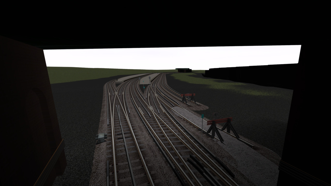
Post by Jimi on Nov 9, 2020 16:11:16 GMT
As promised some pix of the Lower Circle as it develops. Apologies for the delay - as your local news media have likely shown, things have been a little hectic here where I live in the USA. The following were taken as I was driving an S7 between/through the new stations to check for sight lines, infrastructure placement (signals, signs, etc.) which need to be visible to the Operator. We had placed things exactly as per scale diagram, but a few small nudges were needed. Especially ground signals in the six-foot. There are still a few details to polish or add - further lighting, local scenery, etc. but what we have accomplished so far, especially Xavier's atmospheric station modeling, is worth a look.
A FEW MORE PIX OF SOUTH KENSINGTON EAST OF SKN FACING WEST NEAR THE X-OVER
INTO THE TUNNEL NEAR THE PORTAKABINS ONE OF THE OLD VENT AREAS IN THE TUNNEL The following will be new to you. I tried to capture details at various places in each station. There's a lot to see - feels very "Lower Circle".
SLOANE SQUARE
 VICTORIA More as we progress....
|
|